
4Views
1Copies
Nov 17Tested
Tested by bebra · BobloScript editorial team · Nov 17, 2026
Test setup: PC · Potassium
All 4 listed features checked
No failures found.
Tested on PC with Potassium. The road lines drew from the game modules, the map stayed heading-up while driving, and the header drag plus the size buttons and corner grip all responded. No failures were seen during the session.
This reflects one test at a specific point in time, not an ongoing guarantee. How we test scripts
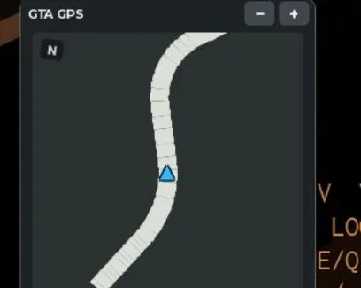
1--========================================================2-- GTA STYLE LIVE MINIMAP V23-- LOCAL CLIENT / EXECUTOR4-- Features:5-- * Live road geometry from game modules6-- * Heading-up map7-- * Large high-contrast player marker8-- * Thicker roads9-- * Drag map by header10-- * Resize with +/- buttons11-- * Resize by dragging bottom-right corner12--========================================================1314local Players = game:GetService("Players")15local ReplicatedStorage = game:GetService("ReplicatedStorage")16local RunService = game:GetService("RunService")17local UserInputService = game:GetService("UserInputService")1819local LP = Players.LocalPlayer20local PlayerGui = LP:WaitForChild("PlayerGui")2122local GUI_NAME = "GTAMinimapV2"23local BIND_NAME = "GTAMinimapV2_Update"2425--========================================================26-- CLEAN PREVIOUS VERSION27--========================================================2829if _G.GTAMinimapV2Cleanup then30 pcall(_G.GTAMinimapV2Cleanup)31end3233local connections = {}3435local function Connect(signal, callback)36 local connection = signal:Connect(callback)37 table.insert(connections, connection)38 return connection39end4041local function Cleanup()42 pcall(function()43 RunService:UnbindFromRenderStep(BIND_NAME)44 end)4546 for _, connection in ipairs(connections) do47 pcall(function()48 connection:Disconnect()49 end)50 end5152 local old = PlayerGui:FindFirstChild(GUI_NAME)53 if old then54 old:Destroy()55 end56end5758_G.GTAMinimapV2Cleanup = Cleanup5960Cleanup()6162--========================================================63-- SETTINGS64--========================================================6566local MAP_SIZE = 2356768local MIN_SIZE = 15069local MAX_SIZE = 35070local SIZE_STEP = 207172local UPDATE_RATE = 0.0873local MAP_PADDING = 07475local ROAD_WIDTH = 15.276local ROAD_OUTLINE_WIDTH = 87778local COLORS = {79 Background = Color3.fromRGB(43, 48, 49),8081 Road = Color3.fromRGB(220, 222, 216),82 RoadOutline = Color3.fromRGB(18, 21, 23),8384 Player = Color3.fromRGB(45, 190, 255),85 PlayerOutline = Color3.fromRGB(255, 255, 255),8687 Header = Color3.fromRGB(29, 34, 36),88 Text = Color3.fromRGB(235, 239, 239),89 Muted = Color3.fromRGB(155, 165, 166),90}9192--========================================================93-- LOAD ORIGINAL GAME ROAD MODULES94--========================================================9596local Shared = ReplicatedStorage:WaitForChild("Shared", 10)97assert(Shared, "Shared folder unavailable")9899local Config = Shared:WaitForChild("Config")100local Rules = Shared:WaitForChild("Rules")101102local RadarConfig = require(Config:WaitForChild("Radar"))103local WorldConfig = require(Config:WaitForChild("World"))104105local RadarRules = require(Rules:WaitForChild("Radar"))106local RoadPathModule = require(Rules:WaitForChild("RoadPath"))107108local RoadPath = RoadPathModule.build(WorldConfig)109110local Bitmap = RadarConfig.Bitmap111112local WORLD_SCALE = Bitmap.Radius / RadarConfig.Range113114-- Vehicle controller115local CarController116117pcall(function()118 local Client = LP:WaitForChild("PlayerScripts")119 :WaitForChild("Client")120121 CarController = require(Client:WaitForChild("CarController"))122end)123124--========================================================125-- VEHICLE DETECTION126--========================================================127128local function GetChassis()129130 if CarController then131 local success, chassis = pcall(function()132 return CarController.viewChassis()133 end)134135 if success136 and typeof(chassis) == "Instance"137 and chassis:IsA("BasePart") then138139 return chassis140 end141 end142143 local character = LP.Character144 if not character then145 return nil146 end147148 local humanoid = character:FindFirstChildOfClass("Humanoid")149 local seat = humanoid and humanoid.SeatPart150151 if not seat then152 return nil153 end154155 local model = seat:FindFirstAncestorOfClass("Model")156157 while model158 and model.Parent159 and model.Parent:IsA("Model") do160161 model = model.Parent162 end163164 if model then165 local chassis = model:FindFirstChild("Chassis", true)166167 if chassis and chassis:IsA("BasePart") then168 return chassis169 end170 end171172 return nil173end174175--========================================================176-- GUI HELPERS177--========================================================178179local function Create(class, properties, parent)180181 local object = Instance.new(class)182183 for key, value in pairs(properties) do184 object[key] = value185 end186187 object.Parent = parent188189 return object190end191192local GUI = Create("ScreenGui", {193 Name = GUI_NAME,194 ResetOnSpawn = false,195 IgnoreGuiInset = true,196 DisplayOrder = 999,197}, PlayerGui)198199--========================================================200-- MAIN CONTAINER201--========================================================202203local Container = Create("Frame", {204 Name = "GPS",205 AnchorPoint = Vector2.new(0, 1),206207 Position = UDim2.new(0, 22, 1, -22),208209 Size = UDim2.fromOffset(210 MAP_SIZE + 20,211 MAP_SIZE + 51212 ),213214 BackgroundColor3 = COLORS.Header,215 BorderSizePixel = 0,216 ClipsDescendants = false,217}, GUI)218219Create("UICorner", {220 CornerRadius = UDim.new(0, 10)221}, Container)222223Create("UIStroke", {224 Color = Color3.fromRGB(105, 115, 118),225 Thickness = 1,226 Transparency = 0.25,227}, Container)228229--========================================================230-- HEADER / DRAG HANDLE231--========================================================232233local Header = Create("TextButton", {234 Name = "DragHandle",235236 Position = UDim2.fromOffset(0, 0),237 Size = UDim2.new(1, -64, 0, 27),238239 BackgroundColor3 = COLORS.Header,240 BackgroundTransparency = 0,241 BorderSizePixel = 0,242243 Text = " GTA GPS",244 TextColor3 = COLORS.Text,245 TextSize = 12,246 Font = Enum.Font.GothamBold,247 TextXAlignment = Enum.TextXAlignment.Left,248249 AutoButtonColor = false,250 ZIndex = 5,251}, Container)252253-- Minus button254local Minus = Create("TextButton", {255 Name = "DecreaseSize",256257 AnchorPoint = Vector2.new(1, 0),258 Position = UDim2.new(1, -35, 0, 3),259 Size = UDim2.fromOffset(26, 21),260261 BackgroundColor3 = Color3.fromRGB(65, 72, 75),262 BorderSizePixel = 0,263264 Text = "−",265 TextColor3 = COLORS.Text,266 TextSize = 17,267 Font = Enum.Font.GothamBold,268269 AutoButtonColor = true,270 ZIndex = 7,271}, Container)272273Create("UICorner", {274 CornerRadius = UDim.new(0, 5)275}, Minus)276277-- Plus button278local Plus = Create("TextButton", {279 Name = "IncreaseSize",280281 AnchorPoint = Vector2.new(1, 0),282 Position = UDim2.new(1, -5, 0, 3),283 Size = UDim2.fromOffset(26, 21),284285 BackgroundColor3 = Color3.fromRGB(65, 72, 75),286 BorderSizePixel = 0,287288 Text = "+",289 TextColor3 = COLORS.Text,290 TextSize = 16,291 Font = Enum.Font.GothamBold,292293 AutoButtonColor = true,294 ZIndex = 7,295}, Container)296297Create("UICorner", {298 CornerRadius = UDim.new(0, 5)299}, Plus)300301--========================================================302-- MAP SURFACE303--========================================================304305local Map = Create("Frame", {306 Name = "MapSurface",307308 Position = UDim2.fromOffset(10, 30),309 Size = UDim2.fromOffset(MAP_SIZE, MAP_SIZE),310311 BackgroundColor3 = COLORS.Background,312 BorderSizePixel = 0,313314 ClipsDescendants = true,315 ZIndex = 1,316}, Container)317318Create("UICorner", {319 CornerRadius = UDim.new(0, 5)320}, Map)321322--========================================================323-- PLAYER MARKER324--========================================================325326local MarkerSize = 0327328local MarkerBacking = Create("Frame", {329 Name = "PlayerBacking",330331 AnchorPoint = Vector2.new(0.5, 0.5),332 Position = UDim2.fromOffset(333 MAP_SIZE / 2,334 MAP_SIZE / 2335 ),336337 Size = UDim2.fromOffset(MarkerSize, MarkerSize),338339 BackgroundColor3 = Color3.fromRGB(12, 20, 24),340 BorderSizePixel = 0,341 ZIndex = 20,342}, Map)343344Create("UICorner", {345 CornerRadius = UDim.new(1, 0)346}, MarkerBacking)347348Create("UIStroke", {349 Color = COLORS.PlayerOutline,350 Thickness = 2,351 Transparency = 0,352}, MarkerBacking)353354local Marker = Create("TextLabel", {355 Name = "PlayerArrow",356357 AnchorPoint = Vector2.new(0.5, 0.5),358 Position = UDim2.fromScale(0.5, 0.5),359360 Size = UDim2.fromScale(1, 1),361362 BackgroundTransparency = 1,363364 Text = "▲",365 TextColor3 = COLORS.Player,366 TextStrokeColor3 = Color3.fromRGB(0, 0, 0),367 TextStrokeTransparency = 0,368369 TextSize = 29,370 Font = Enum.Font.GothamBlack,371372 ZIndex = 21,373}, MarkerBacking)374375--========================================================376-- COMPASS377--========================================================378379local North = Create("TextLabel", {380 Name = "Compass",381382 Position = UDim2.fromOffset(7, 6),383 Size = UDim2.fromOffset(20, 18),384385 BackgroundColor3 = Color3.fromRGB(20, 25, 27),386 BackgroundTransparency = 0.1,387388 Text = "N",389 TextColor3 = COLORS.Text,390 TextSize = 11,391 Font = Enum.Font.GothamBold,392393 ZIndex = 15,394}, Map)395396Create("UICorner", {397 CornerRadius = UDim.new(0, 4)398}, North)399400--========================================================401-- STATUS402--========================================================403404local Status = Create("TextLabel", {405 Name = "GPSStatus",406407 Position = UDim2.fromOffset(10, MAP_SIZE + 32),408 Size = UDim2.new(1, -35, 0, 14),409410 BackgroundTransparency = 1,411412 Text = "GPS // INITIALIZING",413 TextColor3 = COLORS.Muted,414415 TextSize = 10,416 Font = Enum.Font.GothamMedium,417 TextXAlignment = Enum.TextXAlignment.Left,418}, Container)419420--========================================================421-- RESIZE HANDLE422--========================================================423424local ResizeHandle = Create("TextButton", {425 Name = "ResizeGrip",426427 AnchorPoint = Vector2.new(1, 1),428 Position = UDim2.new(1, -3, 1, -3),429430 Size = UDim2.fromOffset(20, 18),431432 BackgroundTransparency = 1,433434 Text = "◢",435 TextColor3 = COLORS.Muted,436 TextSize = 15,437 Font = Enum.Font.GothamBold,438439 AutoButtonColor = false,440 ZIndex = 10,441}, Container)442443--========================================================444-- LIVE SIZE MANAGEMENT445--========================================================446447local function ApplySize(newSize)448449 MAP_SIZE = math.clamp(450 math.floor(newSize),451 MIN_SIZE,452 MAX_SIZE453 )454455 Container.Size = UDim2.fromOffset(456 MAP_SIZE + 20,457 MAP_SIZE + 51458 )459460 Map.Position = UDim2.fromOffset(10, 30)461462 Map.Size = UDim2.fromOffset(463 MAP_SIZE,464 MAP_SIZE465 )466467 MarkerBacking.Position = UDim2.fromOffset(468 MAP_SIZE / 2,469 MAP_SIZE / 2470 )471472 MarkerSize = math.clamp(MAP_SIZE * 0, 0, 0)473474 MarkerBacking.Size = UDim2.fromOffset(475 MarkerSize,476 MarkerSize477 )478479 Marker.TextSize = 35480481 Status.Position = UDim2.fromOffset(482 10,483 MAP_SIZE + 32484 )485486 North.Position = UDim2.fromOffset(7, 6)487end488489Connect(Minus.Activated, function()490 ApplySize(MAP_SIZE - SIZE_STEP)491end)492493Connect(Plus.Activated, function()494 ApplySize(MAP_SIZE + SIZE_STEP)495end)496497--========================================================498-- DRAG AND RESIZE CONTROLS499--========================================================500501local interaction = nil502503local function StartInteraction(handle, mode)504505 Connect(handle.InputBegan, function(input)506507 local inputType = input.UserInputType508509 if inputType ~= Enum.UserInputType.MouseButton1510 and inputType ~= Enum.UserInputType.Touch then511 return512 end513514 interaction = {515 mode = mode,516 inputType = inputType,517518 startPointer = input.Position,519520 startPosition = Container.Position,521 startSize = MAP_SIZE,522 }523 end)524end525526-- Drag by header527StartInteraction(Header, "drag")528529-- Resize by corner530StartInteraction(ResizeHandle, "resize")531532Connect(UserInputService.InputChanged, function(input)533534 if not interaction then535 return536 end537538 local isMouse =539 interaction.inputType == Enum.UserInputType.MouseButton1540 and input.UserInputType == Enum.UserInputType.MouseMovement541542 local isTouch =543 interaction.inputType == Enum.UserInputType.Touch544 and input.UserInputType == Enum.UserInputType.Touch545546 if not isMouse and not isTouch then547 return548 end549550 local delta = input.Position - interaction.startPointer551552 if interaction.mode == "drag" then553554 local start = interaction.startPosition555556 Container.Position = UDim2.new(557 start.X.Scale,558 start.X.Offset + delta.X,559560 start.Y.Scale,561 start.Y.Offset + delta.Y562 )563564 elseif interaction.mode == "resize" then565566 local change = (delta.X + delta.Y) * 0.5567568 ApplySize(interaction.startSize + change)569570 end571end)572573Connect(UserInputService.InputEnded, function(input)574575 if not interaction then576 return577 end578579 if input.UserInputType == interaction.inputType then580 interaction = nil581 end582end)583584--========================================================585-- ROAD DRAWING586--========================================================587588local Segments = {}589590local function NewSegment()591592 local outline = Create("Frame", {593 Name = "RoadOutline",594595 AnchorPoint = Vector2.new(0.5, 0.5),596597 BackgroundColor3 = COLORS.RoadOutline,598 BorderSizePixel = 0,599600 Visible = false,601 ZIndex = 3,602 }, Map)603604 local road = Create("Frame", {605 Name = "Road",606607 AnchorPoint = Vector2.new(0.5, 0.5),608609 BackgroundColor3 = COLORS.Road,610 BorderSizePixel = 0,611612 Visible = false,613 ZIndex = 4,614 }, Map)615616 return {617 Outline = outline,618 Road = road,619 }620end621622local function DrawSegment(index, x1, y1, x2, y2)623624 local item = Segments[index]625626 if not item then627 item = NewSegment()628 Segments[index] = item629 end630631 local dx = x2 - x1632 local dy = y2 - y1633634 local length = math.sqrt(dx * dx + dy * dy)635636 if length < 0.5 then637 item.Outline.Visible = false638 item.Road.Visible = false639 return640 end641642 local position = UDim2.fromOffset(643 (x1 + x2) * 0.5,644 (y1 + y2) * 0.5645 )646647 local rotation = math.deg(math.atan2(dy, dx))648649 item.Outline.Position = position650 item.Outline.Size = UDim2.fromOffset(651 length,652 ROAD_OUTLINE_WIDTH * (MAP_SIZE / 235)653 )654 item.Outline.Rotation = rotation655 item.Outline.Visible = true656657 item.Road.Position = position658 item.Road.Size = UDim2.fromOffset(659 length,660 ROAD_WIDTH * (MAP_SIZE / 235)661 )662 item.Road.Rotation = rotation663 item.Road.Visible = true664end665666local function HideUnused(count)667668 for index = count + 1, #Segments do669 Segments[index].Outline.Visible = false670 Segments[index].Road.Visible = false671 end672end673674--========================================================675-- ORIGINAL ROAD GEOMETRY676--========================================================677678local function UpdateRoad(chassis)679680 local progress = RoadPathModule.project(681 RoadPath,682 chassis.Position.X,683 chassis.Position.Z684 )685686 if typeof(progress) ~= "number" then687 HideUnused(0)688 return false689 end690691 -- The same road-line generator as PassengerRadar.692 local worldPoints = RadarRules.roadLine(693 RoadPathModule,694 RoadPath,695 progress,696 RadarConfig697 )698699 local points = {}700701 local factor = MAP_SIZE / (Bitmap.Radius * 2)702703 for _, worldPoint in ipairs(worldPoints) do704705 -- Original game coordinate conversion.706 -- Coordinates are relative to vehicle orientation,707 -- so the map automatically rotates with the car.708709 local x, y = RadarRules.toRadar(710 chassis.CFrame,711 worldPoint,712 WORLD_SCALE713 )714715 if typeof(x) == "number" and typeof(y) == "number" then716717 table.insert(points, {718 x = MAP_SIZE / 2 + x * factor,719 y = MAP_SIZE / 2 + y * factor,720 })721722 end723 end724725 local count = 0726727 for index = 1, #points - 1 do728729 local a = points[index]730 local b = points[index + 1]731732 -- Ignore completely distant segments.733 if math.abs(a.x - MAP_SIZE / 2) < MAP_SIZE * 2734 or math.abs(b.x - MAP_SIZE / 2) < MAP_SIZE * 2 then735736 if math.abs(a.y - MAP_SIZE / 2) < MAP_SIZE * 2737 or math.abs(b.y - MAP_SIZE / 2) < MAP_SIZE * 2 then738739 count += 1740741 DrawSegment(742 count,743 a.x, a.y,744 b.x, b.y745 )746 end747 end748 end749750 HideUnused(count)751752 return count > 0753end754755--========================================================756-- MAIN LOOP757--========================================================758759local timer = 0760761local function Update(dt)762763 timer += dt764765 if timer < UPDATE_RATE then766 return767 end768769 timer = 0770771 local chassis = GetChassis()772773 if not chassis or not chassis.Parent then774775 Status.Text = "GPS // NO VEHICLE"776777 HideUnused(0)778779 return780 end781782 -- The compass rotates to show the north direction.783 local look = chassis.CFrame.LookVector784785 local heading = math.deg(786 math.atan2(-look.X, -look.Z)787 )788789 North.Rotation = heading790791 -- Marker remains at the center, facing forward.792 Marker.Rotation = 0793 MarkerBacking.Rotation = 0794795 local success, result = pcall(function()796 return UpdateRoad(chassis)797 end)798799 if not success then800801 Status.Text = "GPS // ROAD ERROR"802803 HideUnused(0)804805 warn("[GTAMinimapV2] Road calculation error:", result)806807 return808 end809810 if result then811 Status.Text = "GPS // LIVE"812 else813 Status.Text = "GPS // NO ROAD"814 end815end816817--========================================================818-- START819--========================================================820821ApplySize(MAP_SIZE)822823RunService:BindToRenderStep(824 BIND_NAME,825 Enum.RenderPriority.Last.Value,826 Update827)828829print("--------------------------------------")830print("[GTAMinimapV2] Started")831print("[GTAMinimapV2] Drag header to move")832print("[GTAMinimapV2] +/- buttons change size")833print("[GTAMinimapV2] Drag bottom-right to resize")834print("[GTAMinimapV2] Live local road geometry")835print("--------------------------------------")A draggable minimap that reads the game's own road geometry and draws it in the bottom-right corner. The map is heading-up, so the road layout turns with the car instead of staying fixed to north. The center marker stays in place while the road segments move and rotate around it.
Road lines are projected from the game's Shared Config and Rules modules, then clipped to the map surface. If those modules are renamed or removed by an update, the map shows NO ROAD or ROAD ERROR instead of drawing.
The status line reports LIVE, NO VEHICLE, NO ROAD, or ROAD ERROR. NO VEHICLE means no chassis was found from the car controller or the seat hierarchy.
Drag the header to move the panel. The + and − buttons step the size, and the bottom-right grip resizes continuously. Size is clamped between 150 and 350 pixels.
The north label rotates to show north relative to the car, while the player arrow stays fixed at the center.
The script rebuilds its GUI on re-execution and unbinds its render step, so running it again replaces the old map instead of stacking a second one. Tested on PC with Potassium.
Windows
 Madium
 Potassium
 Real
 Sirhurt
 Velocity
 Volt
 Wave
 Volcano
Android
 Delta
iOS
DeltamacOS
 Opiumware
Windows
 Solara
 Xeno
by make sure to drive fast · 1 script · 4 views
Browse
Script Types
Tools
Community
Comments
Loading comments…